Subject: TS Milton forms in the Gulf of Mexico

AlertsUSA Logo - Allow Images

SMS Alert Text:


TS Milton forms in the Gulf of Mexico. Forecast to quickly intensify on approach to the Florida coast. Eastern Gulf interests should be monitoring this system.


Supplemental Info:


Tropical Storm Milton Main Storm Page:

https://www.nhc.noaa.gov/refresh/graphics_at4+shtml/204837.shtml?cone#contents


Storm Discussion:

https://www.nhc.noaa.gov/text/refresh/MIATCDAT4+shtml/052046.shtml?


Key Messages:


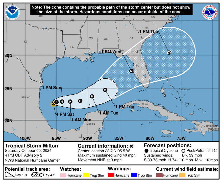
1. Milton is forecast to quickly intensify while it moves eastward to northeastward across the Gulf of Mexico and be at or near major hurricane strength when it reaches the west coast of the Florida Peninsula mid week.


2. There is an increasing risk of life-threatening storm surge and wind impacts for portions of the west coast of the Florida Peninsula beginning late Tuesday or Wednesday. Residents in these areas should ensure they have their hurricane plan in place, follow any advice given by local officials, and check back for updates to the forecast.


3. Areas of heavy rainfall will impact portions of Florida Sunday and Monday well ahead of Milton, with heavy rainfall more directly related to the system expected later on Tuesday through Wednesday night. This rainfall brings the risk of flash, urban, and areal flooding, along with minor to moderate river flooding.


Traffic and Road Conditions


The potential for dangerous flooding with a coastal hurricane impact is high. As a result, increased situational awareness is advised if you or family members are heading out on the roads during such weather events.


National 511 System


On July 21, 2000, the FCC assigned 511 as a nationwide telephone number for intelligent transportation system (ITS) traveler information. Managed by the Federal Highway Admin. (FHWA), the system allows drivers to dial “511" on their phones and receive real-time traffic information. Depending on the time and system load, you will either hear recorded messages or speak directly with a human operator who can provide traffic information.


The websites below, covering states with normal potential for hurricane impact, provide interactive maps with real-time information on road conditions. All are accessible via mobile devices:


Service Notes:

This email message is a component of the AlertsUSA Homeland Security Threat and Incident Notification Service for mobile devices. You have paid for this service and are encouraged to archive these messages.


Service Issues? Let Us Know:

service@AlertsUSA.com


Discount Subscription (share w/ friends):

https://AlertsUSA.com/pages/ausab7


Threat Journal Weekly Newsletter:

https://ThreatJournal.com


Connect With Us On Social Media:

Twitter: AlertsUSA

Twitter: ThreatJournal

Facebook: AlertsUSA

AlertsUSA

Homeland Security Threat and Incident
Notification via Your Mobile Device